
![]()
Undated Flood at Banff, Alberta, Canada
 |
Perhaps someone who knows the topography
could orient me as to what mountains are in the background.
In response to the note above, I received an email from Joe Owchar
January 23, 2006. He tells me that the peak on the left is looking
west to an unnamed peak of
the Sundance Range; Mt Bourgeau and Mt Brett are to the right. He
guesses that it would be May or June which makes sense given when the
spring freshet would be. Mt Bourgeau is near Sunshine Village - I am
guessing this photo is looking east. See: http://www.peakfinder.com/peakfinder.ASP?PeakName=mount+bourgeau |
 |
This is a washout in front of the Banff CPR Station. |
 |
Obviously the cart from Banff Meat Market had seen better days! Joe Owchar in his email also deduces that since the water can only be moving toward the camera in the meat wagon photo,that "it's one of the those 1/100 year events when 40 Mile Creek burst its banks". His great grandfather, Edward BROWN came to work in Bankhead around 1900. |
Banff Springs Hotel Reconstruction
|
Robert Brown and relatives in Banff, Alberta, Canada
|
|
Family photos from Banff
|
|
 |
This is one of those mystery photos. Taken where
or when - I don't know. If anyone recognizes the skyline, perhaps they
can help. Update: November 24: An email from Tim Dueck saw this skyline in an old postcard, and he is right - it is the same from a slightly different perspective. |
 |
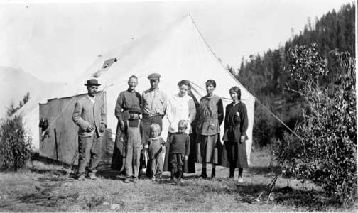
| This is an early camping trip. Jeannie (aka "Jane"
aka "June") Edgar BROWN is wearing the white sweater. It has
been suggested that they were likely camping at Sanka, currently a very
small settlement on the shores of the Kootenay Lake, BC. The suggested
date is 1915. The family would have been living in Cranbrook, BC at the
time. The other people are yet to be identified. Sharon Oddie Brown, August
2003. |
Site Map | Legal Disclaimer | Copyright
© 2006-2023 Sharon Oddie Brown